Explainer: Natural Resource Protections: the most under-appreciated project to protect our ecosystem
Part of an ongoing series of “explainers” and FAQs about our work at the Alliance.
We all know that Jackson Hole, and the entire Greater Yellowstone Ecosystem, have some of the greatest natural resources in the lower 48 – if not the entire planet. We have clean air, clear water, abundant habitat, migration corridors and free-roaming charismatic wildlife. At the Alliance, we work to protect these “resources” in many different arenas – we advocate with public land managers like the national parks, wildlife managers like the Wyoming Game & Fish, state legislators in Cheyenne, and probably most effectively, local governments: our Jackson Town Council and Teton County Board of County Commissioners. Today we’re going to focus on the often un-sung local land-use decisions that protect what we love about this place. We’ll use a Frequently Asked Questions (FAQ) format – and we welcome your questions too!
What is our Comprehensive Plan?
The “Comp Plan” is our vision for what we want to be when we grow up. Think of it as a blueprint. Our community created our first Comp Plan in 1978, in response to sprawling development threatening what local residents loved about Jackson Hole – the open spaces, the close-knit community, the wildlife habitat. Coincidentally, the Alliance was formed out of the fight to adopt and then protect that first Comp Plan – so we like to say “planning is in our DNA.” The community updated the plan in 1994 and most recently in 2012. The 2012 Comp Plan contains an incredible vision – the core is: “protect and preserve the area’s ecosystem.” The Comp Plan is not a legal document though – it doesn’t have “teeth.”
What are LDRs?
The Land Development Regulations (LDRs) implement the vision from the Comp Plan – they turn that broad vision into rules and laws. You may know LDRs from specific zones like “downtown LDRs” or “Rural LDRs” or “Wilson LDRs,” etc. Generally, LDRs govern what you can build on your property – how tall, how dense, how much parking, how far setback from neighbors. All within the parameters established by state statute – and then the county has the authority to set zoning rules for the health, safety, and welfare of our community. Sidenote – this local control is under threat at the state legislature in Cheyenne.
What about overlays?
In addition to the zones, there’s another tool called “overlays” that apply on top of whatever zone you may be in. You may have heard of the “Lodging Overlay” – it’s another line on the map that crosses multiple zones. If you’re in it, you can do short-term rental like AirBnB. If you’re outside of it, you can’t. We also have a Scenic Resource Overlay (SRO) that protects views – and a Natural Resource Overlay (NRO) that protects valuable habitat. If you’re in the NRO, the county has a bit more authority on where you can build, and can prohibit certain high-intensity uses (but all landowners still maintain their basic property rights).
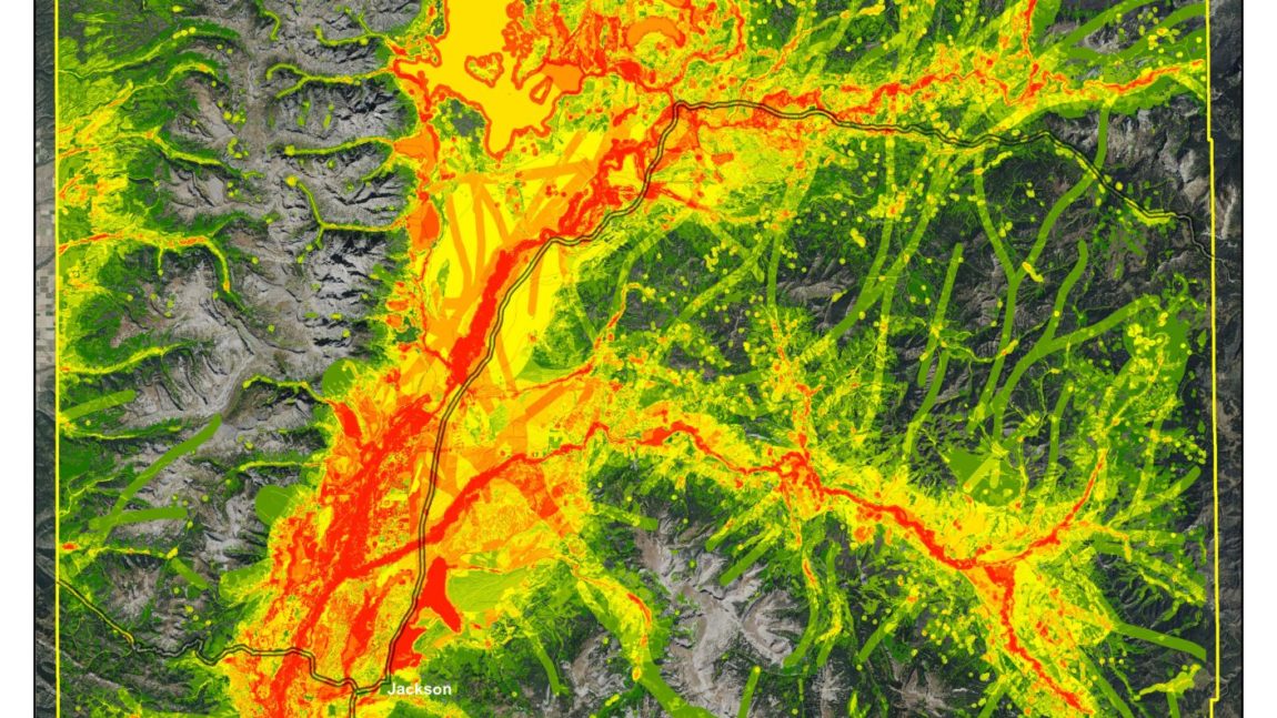
Right now, the NRO is a line on the map. You’re either inside it or you’re outside it. Landowners often challenge the line. So the county hired a consultant to develop a new, more science-based, map. This map is called the Focal Species Habitat Map Ecologists worked with a volunteer committee (the Natural Resources Technical Advisory Board, or NRTAB) to identity key species at the landscape (county-wide) level, and then use GIS to identify which locations of the county are suitable habitat for those species, and then add it all up to say which parts of the county are more or less important habitat across the board. You can read all about the new map here. The next step is to turn that map into a few different tiers – a “low,” “medium,” and “high” tier with increasing protections.
So how does all that relate to the Natural Resource LDRs?
The Natural Resource (NR) LDRs do two things: (1) they are the special rules that apply in the NRO, and (2) there are other rules that apply everywhere in the county. Generally, the NR LDRs don’t change the basic zoning framework – they don’t remove density or property rights, they don’t change the height of buildings. They do control where you can build. So if you have very valuable wildlife habitat on your property, the NR LDRs can say “don’t build there, build in less valuable habitat.” And what rules should we have countywide? Bear proof trash cans, protection of water bodies. And how can we set up incentives, so that we encourage people to do better than they have to? How can we fund that? All of that is on the table.
What is the NRSG?
The Natural Resources Stakeholder Group (NRSG) is another volunteer committee hosted by the county. We’ve had a representative on the NRSG since its founding, currently our Executive Director Skye Schell (who joined the group in late 2017). The mission of this group was to advise county planning staff as they develop a draft of the new NR LDRs, so that the draft is pre-vetted and will have broad community support. (A much better way to do things than just writing a draft and seeing what people think after it’s done.) The group included conservationists like us and Chris Colligan from the Greater Yellowstone Coalition; landowner and developer representatives like Kelly Lockhart, Scott Pierson and Cornelius Kinsey environmental consultants like Anna DiSanto (a CLI graduate!); agency reps like Aly Courtemanch and Anna Senecal from WGF and Tom Segerstrom from Teton Conservation District; and Hank Phibbs joined as the property rights advocate. Overall, a diverse group. I have been very impressed at how well this group has worked together.
What happened?
Rewinding to 2017 – the county gathered a lot of public input in their “Engage2017” outreach project, and then the county commission set initial high-level direction – basically, yes, we want strong NR protections, but maybe less so in zones intended for more density (complete neighborhoods).
Then the NRSG worked on three interlocking pieces with the county staff and stakeholders:
- How do you set up and use the map? What are the cutoff points between the tiers?
- What should be the rules for each tier? Especially, how do you locate development in each tier?
- What are the countywide rules for everywhere
The goal was to finish a draft in 2018 and get it adopted by the commission before they turned over.
Unfortunately, we got really bogged down in the question of using the map and locating development. The NRSG and staff did fantastic work, going through hard questions, disagreements, and generally agreed on one approach. Unfortunately, the NRSG had a long-running miscommunication with staff, and the first draft of the rules in September didn’t match what the group had agreed on. The draft also didn’t include some key areas – fencing regs, migration corridor protections, wildlife “movement” more generally – because we didn’t have time. So, realizing we weren’t going to hit the deadline, the county pressed pause (see Allie Gross’ coverage in the News & Guide). Then, the two staff who had been working with us both left the county – Alex Norton started his own business & Roby Hurley retired.
Where are we now?
Most of the NRSG is trying to get the county to keep the ball rolling. The county has 4-5 open planning positions, so they don’t have the staff to manage the project right now. Speaking just for the Alliance: as soon as the county re-hires planning staff, we want them to prioritize completing the NR LDRs. We want the county to hire a consultant to facilitate a few more NRSG meetings – get clarity on what the group agreed on in terms of map & process, and then dive into fencing, migration, incentives, etc. We would like all this to happen in the 1st half of 2019, and get it all done in 2019.
What can you do?
- You can drop a line to the county commission and planning staff encouraging them to prioritize NR LDRs anytime at commissioners@tetoncountywy.gov.
- And if you let us know, we’ll keep you posted so that when this does come forward, you can write in then.